Random Street View – images from all over the world.
Marvellous! Does what it says on the tin. I found a great one on Eigg that seemed to be from a hill track. Couldn’t get the share link to work though.
via Joe Jennet

Random Street View – images from all over the world.
Marvellous! Does what it says on the tin. I found a great one on Eigg that seemed to be from a hill track. Couldn’t get the share link to work though.
via Joe Jennet
I occasionally make simple mashup of of gpx, google maps and flickr photos of walks. I record gpx on the Trails app on my phone, take photos with the phone too as they are nicely geo tagged and flickr can use that information and provide in the API 1.
One of the things I noticed was that the GPX files can be pretty big, over a megabyte each. I know there was probably a lot of information in the file that was not needed to display the path on the map but was not sure of how to do so easily. I think I’ve used online services for this before. Finding a site, uploading a file and downloading is a lot of bother for something that I hope will be quick and simple. I also expect that the audience for the pages produced is one.
Having a look inside the gpx files I though that you could probably slim them down considerably, each point is recorded like this:
<trkpt lat="55.996687" lon="-4.389713"><ele>188.609</ele><time>2016-06-05T10:12:58Z</time><extensions><gpxtpx:TrackPointExtension><gpxtpx:speed>1.30</gpxtpx:speed><gpxtpx:course>206.37</gpxtpx:course></gpxtpx:TrackPointExtension><trailsio:TrackPointExtension><trailsio:hacc>5.00</trailsio:hacc><trailsio:vacc>3.00</trailsio:vacc><trailsio:steps>2</trailsio:steps></trailsio:TrackPointExtension></extensions></trkpt>
I am pretty sure all we need is:
<trkpt lat="55.996687" lon="-4.389713"><ele>188.609</ele></trkpt>
and that a regular expression could do the trick.
I don’t know anything about RegEx other than I’ve found it offered as a solution when googling text replacement problems but this:
replace: <extensions>.*?</extensions> with nothing
followed by replace: <time>.*?</time> with nothing
I am guessing I could combine these, but it didn’t take long to run through a few files using them in this crude form.
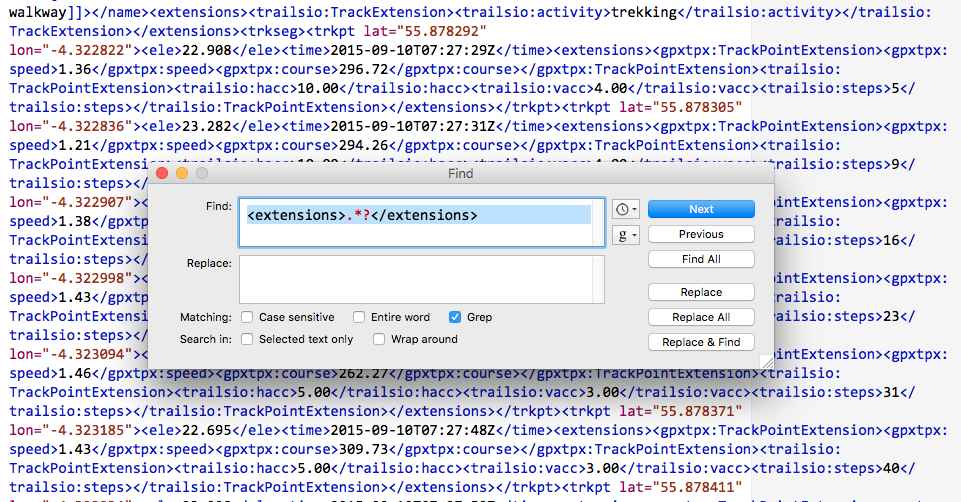
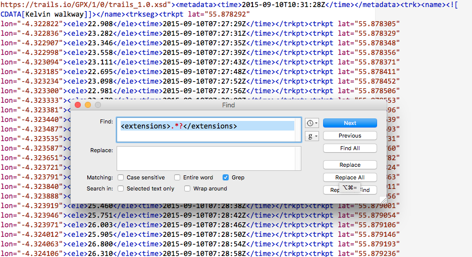
did the trick. My 1MB file was now 160KB
This works both in BBEdit and TextMate. TextMate struggled a bit with the size of the files.
This post will be of little interest to anyone but myself and might just fit in the suchlike bit of this blogs sub title.
Featured Image: two screenshots, layered. my own CC-BY.
I’ve been keeping half an eye on the digital commonwealth project since talking to David on Edutalk. Last weekend I was doing a little blogging about the project and taking a short walk or two. One of the many attractive aspects of the project is that it invites people to think about the word and concept of commonwealth. Coincidently I read, not for the first time, a newish sign on the path to Loch Humphrey.
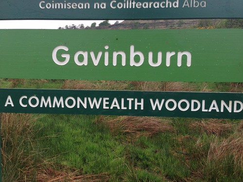
This is an area I’ve started to really enjoy over the last few years. I feel it fits very well with my idea of commonwealth.
The start of the walk, by the gasworks, is about 15 minutes drive from Glasgow, and near public transport. It is popular, runners, mountain bikers, power walkers, ramblers of all shapes and sizes are there early to late. There is a fairly well graded track to the Loch if you need to keep your feet dry, or you can zig-zag the fields and moor. You will usually see a few wild flowers and the odd bit of wild life if you keep your eyes open. Once you are past the first hill the traffic noise stops. Out beyond the Loch it feels surprisingly isolated if you are early enough.
This seems to me to be a precious resource and although owned by farmers and the forestry commission (I guess), it feels as if some of the experience is part of our common wealth.
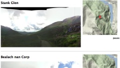
Over the years I’ve made efforts to record walks in various ways, posterous, fargo, and lots of map mashups. Recently I’ve had another go at this, this time trying to really simplify the workflow. I’ve ended up with a html template that uses a kml file produced by the Trails iPhone app and a flickr set. So to produce a page like this: Duncolm Mostly Floral I:
I think this could be improved as a workflow with some sort of simple template. This would contain on separate line: A title; the flickr set’s id; the kml file and the notes.
I’ve been fascinated with sort of recording/notetalking/storytelling for a fair while now and it is sort of my unofficial ‘digital commonwealth’.
I continue to see that this sort of activity could be great fun in class and there many ways to mash up maps, words and images. Wouldn’t it be great if the new glow blog solution had a Geo-Rss plugin for fold to activate.
I’d recommend showing the digital commonwealth to your class, whatever age and stage and at least borrowing some of the ideas for using digital media, if you do not join in. If you do want to join in I believe there are still places for a few more schools to receive some support.
David tell me there is still room for a few more schools and you can get in touch via email or twitter: DigCW2014. They are particularly need schools in Borders, Angus, Perth & Kinross, W Lothian, Clackmannan, Stirling, W Dunbartonshire, East Ren, Renfrewshire.
Make a custom map using Google Maps.
Use Google Maps to create your own custom map that includes photographs of places.
I’ve been playing with google maps and the google maps api for a while so was please t osee some familiar territory for this Assignment.
This afternoon Dorothy, my wife, and I took a walk round Ardinning Loch, we do this nearly every week often twice a week in the summer, It is a short walk that is always interesting. Ardinning is a SWT reserve.
I used Trails on my phone to record a kml and gps track. The kml file was imported int oa new google map. I uploaded the photos it was then just a matter of dropping on some pins, filling in a title and pasting in the url to the image file.
View Ardinning in a larger map
Over the last few year I’ve played with developing a workflow for creating maps like this using the GoogleMaps API. For this I use SuperCard, a mac scripting application. The project allows me to import a gpx file exported from Trails, get exif data for some pictures, iPhone photos have location data imbedded (It also lets me add locations to other pictures by comparing the time taken with the gps file). It then exports a gpx file which I upload to this website and a php file created a map.
Here is the Ardinning Walk map 120303 Ardinning and a whole set of Mapped Walks. In my opinion this has a few advantages over using google maps, you can embed audio & video, and the popup boxes link in sequence. It is also a faster to produce. Obviously it has the disadvantage of being a wee bit trickier to set up.
I’ve a fair number of blog posts going into this in a bit more detail: tagged googlemaps.
I think these sort of maps add another dimension to telling a story or presenting information. helping to tell a story in space as well as time. I can see this being incorporated into all sorts of class room projects, either for mapping learning experiences or creating fictional maps. This one The Kidnapped Trail – Google Maps is a great example of the possibilities.
It loks like I can kill two birds here: Google Maps Story — MISSION: DS106
I’ve been interested in combining maps and media for a while now. Here is a recap of some of the methods I’ve been using. I’ve not often had the chance to do this sort of thing in a teaching situation but continue to believe that mapping media would be a valuable way to record experiences for pupils and a nice slant on digital storytelling.
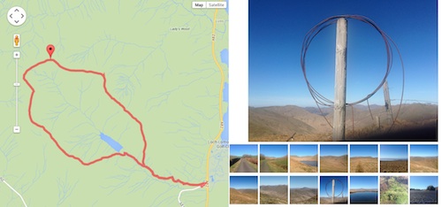
Last Sunday I had a walk to Benvane & Ben Ledi recorded the gpx with the iPhone Trails app (one of my top 10 apps) took photos, video and some panoramas. Here are the three ways I’ve been developing of displaying them on the web. None of these are good as examples of story telling as I am still thinking about the workflow and tech.
I’ve built up a fair collection of these over the last few years. this one only uses iPhone photos which means I can skip the stage of matching photos to the gpx file. When I started doing these google maps API was at version 1, I move to 2 and now am behind version 3.
This is the most conventional story combining an image with text in a liner fashion along the track.
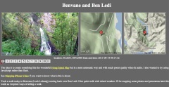
Benvane and Ben Ledi video map
I just blogged about this in the previous post
I am hoping that this can produce a more contemplative result.
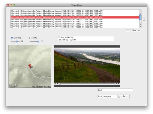
Although I’ve only just worked out how to do this the workflow is a lot simpler than the photo maps. I’ve developed a mac application (using SuperCard) to make these. All I need to do is to drag some iphone videos out of iPhoto onto the application and it creates the smaller versions of the video and the HTML to display them along side the maps
I you have a mac and would be interested in trying the app, let me know.
This is the most recent development, after tweeting about the Video Maps @drewburrett suggested using photosynth for the iPhone to take pano photos and do something similar. I’ve not got a workflow for creating these and don’t think I’ve got the display method right yet but I am quite excited about working out different ways to present pano photos.
As I said I’ve been messing with maps and media for a long time (2006 example) I’ve blogged about it a fair bit, pretty much in a vacuum. I’d be really interested in finding some folk to play along with or a school interested in trying out some of this stuff.
I’ve blogged before about the wonderful Hmsg Spiral Map a project that combines video, audio and google maps into a mesmerising meditative experience.
Recently I noticed that iPhoto shows the location of videos as well as audio which got me thinking a wee bit. I checked out a few exif tools and found that the location was stored in exif data in the same way as photos.
I already had made some crude tools to map walks on google maps and made an odd foray into adding sounds to the photos: burn, so though I might be able to knit together some video and maps.
After a few false starts I manage to do this:
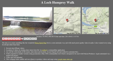
This is a webpage that shows a series of videos with a couple of maps pointing to the location the video was shot at. When one video ends the next is automatically loaded. You can jump around by clicking the numbers.It information: videos urls, locations and time shot is stored in an xml file, this is loaded by some javascript (jquery)
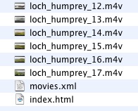
The list of movies and locations are loaded from an xml file that is a very simple list:
<item><file>loch_humprey_02.m4v</file><loc>55.9323,-004.4594</loc><dc> 2011:08:02 21:27:10</dc></item>
I though xml was a good idea as it would allow reuse to display the movie in different ways. As the movies are shown the location is used to show a couple of images using the google maps static api. This first Video Map Experiment was cobbled together using a couple of command line tools (pcastaction, built into Mac OS X and ExifTool by Phil Harvey). I am not knowledgeable about shell stuff but it can often help do interesting things and once you figure it out is easy to reuse.
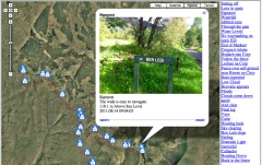
After a couple of tries I’ve made a Supercard project that sorts this all out, here is what I did to make the A Loch Humphrey Walk
I then upload folder to server via ftp.
Getting the JavaScript stuff sorted out took me a wee while and quite a few wrong turnings, but it all seems to work on both Mac & Windows with FireFox, Safari or IE now. I started to write about the gory details in this post, but decided to split them off and I’ll put them up somewhere else sometime soon. I also hope to make the Supercard Project available for anyone who is interested. (If you want to see an early version let me know)
I hope this could be an interesting way to tell a story, record a trip or describe a place. I’d be interested to know what other folk think.
On Friday evening I went along to the evening presentation and discussion part of this event. There had been an afternoon training workshop on the practicalities of field recording run by the evenings presenters which was limited in numbers. My attention to the event had been aroused by a tweet from @scottishmusic I guess because I post the odd recording to the UK Sound Map. The evening was a little bit different from the educational conference/teachmeet meetings that I am more likely to be found at but I am really glad I went.
The first presentation was by theatre maker Tim Nunn of the company Reeling & Writhing (404 Archive link). He spoke about his work in progress Formel, inspired by Chaucer’s Assembly of Fowls the play uses field recordings extensively. Tim spoke about how he wrote the play working back and forward between text & field recording each affecting the other. A lot of the sound was recorded on Islay and he played us fragments of a force 10 gale and rooks mobbing an eagle. Here is a taste of the play I found on the Formel page
‘Formel’ by Tim Nunn, trailer by timjnunn
Tim mentioned RJ McConnell (site gone, archive link) as the person behind the sound of the play, whose blog will take you in other interesting aural directions
Formel has had a couple of preview performances and is due to be on tour at he end of this year or the start of the next (as far as I picked up) and is certainly something I would like to go along to.
Next we heard from Timothy Cooper Timothy let us here kaktos the sounds of this were made by plucking of cactus spines. He showed us Postcards from blast beach which featured photos by his father and sounds recorded and edited by Timothy. A quick google found the video on My Space.
Next he played Skate ‘n’ Shuttle/Roll and Smash:
Skate n Shuttle/Roll and Smash by tim_bo
As someone who is as musical as a turnip I can’t really comment on the work, other than to say I enjoyed listening to it. The Blast Beach images & sound was interesting in being a very much polished combination of photos and edited found sound. As someone who takes phone photos and records the odd sound when out and about it shows where the idea can go give a deal of talent in photography & music.
Ian Rawes spoke about several sound map mashups. Starting with his own London Sound Survey which features London maps, ambient sound recordings, sound maps, local history & London wildlife. This is a site to get lost in, the quote on the front page Perhaps the most ambitious and comprehensive approach to sound mapping I’ve yet to see . . . an all-around wonderful site! (from Jim Cummings, Acoustic Ecology Institute) rather understates it! Ian is the Vault Keeper at the British Library sound archive (I think). Ian briefly showed us round the London Sound Survey playing recording of a street preacher (there are quite a few) and a Common Pipistrelle bat recorded with a Magenta heterodyne bat detector set to 45 kHz and Edirol R09-Hr digital recorder which gives you an idea of the range of the site if not the depth. He also showed us the London map with present-day streetmaps, historical maps and sound recordings.
Ian is also the person behind the UK Sound Map , I’ve blogged about this before and contributed a few boos to the map. what I love about the project is the fact that it is open to anybody to contribute, it is easy to do so and it mashes maps & sound.
We then saw the Acoustic map from 12 Gates to the City The acoustic map is an ever-growing collection of 1 to 5 minute sound recordings embedded on a world map at the exact location of each recording. created by Jonathan Prior, an Edinburgh-based creative researcher, who was sitting in the audience. Johnathan’s map is interesting because it uses UMapper rather than google maps, it looks and sounds good. We heard the underwater recording of periwinkles grazing on algae which sound nothing like you would expect. It looks as if there is a lot of interesting stuff on 12 Gates to the City.
The Inukjuak Sound Map is another map sound mashup this time created by Montreal sound artist Nimalan Yoganathan. The map has cultural and natural sounds, some with images. It uses google maps. We also watched Charles Veasey’s Hmsg Spiral Map which I had seen before, but it was interesting watching with other people on a large screen rather than in one’s own home with multiple on and offline distractions. The Hmsg project is a flash/video/google maps mashup.
One of the main impressions I got from the event was the quality of the audience’s listening, this made the evening quite quiet and contemplative, quite different from, say, a TeachMeet or educational tech event. I had not taken a laptop or ipad to take notes, but if I had I would not have used them, I didn’t take any photos either although I had a phone with me. In googling the links for this post I re read Inukjuak Sound Map and Hmsg Spiral Map on Ian’s London Sound Survey blog:
The Spiral Map looks and sounds very impressive as it progresses smoothly through its 30 different sound recordings and videos. Most of the videos have very little motion in them and much more action is heard than seen. It’s a great way to set a balance between the ravenous eye and the patient ear.
I came away straight after the event, an empty stomach and dinner waiting kept me from the pub, with open ears, walking to the train station listening more than usual. At the station I was surprised that the announcement and the clicking and clacking of the high heeled shoes were louder than the train.
I’ve also been thinking of how this could relate to the classroom. Here are some ideas off the top of my head:
In the afternoon workshop there had, I think, been a lot more technical information. Ian provides a Budget binaural stereo microphones guide on London Sound Survey. A lot of the Field Recording crowd seem to know what they are talking about kit wise, I was somewhat relieved when Ian appropriated the Best Camera quote: The best microphone is the one you have with you.
In talking about UMapper, Ian said it was in some ways easier to use than google maps. This is probably right, but I like the way google maps can be use to auto update, using the api, so that things are added without automatically, without crafting
Finally what I’d take away was the quality of listening shown by the audience & presenters. The time taken. Timothy Cooper’s Blast beach gave plenty of time to look at the images: audio can be slower. I am thinking again about Ian Rawes’ “the ravenous eye and the patient ear”, Tim Nunn’s theatre performances in the dark.
From the above you can see I’ve gathered a great number of links, sites not only to visit but to revisit. It is not often you get the chance to hear periwinkles eating.
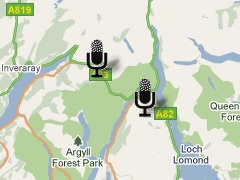
I love Audioboo. We use it as one of the ways to publish to edutalk.info and I’ve joined in tagging some boos uksm for the UK Sound Map project.
Audioboo must be one of the simplest ways to do audio podcasting and it has many nice features. One of the ones that interests me most is the fact that the RSS feed has geo information in it, that is the location that the boo was recorded in (users can I believe turn this off). I have played about with the google maps api in simple ways (eg some walks) and really like the ability to tell a story in space as well as time.
Yesterday I though I’d have a look at the Audio Boo RSS feed (atom really) and see if I could do something similar.
Since google maps support GEORSS I though I’d give that a try first, pasting my audioboo feed into the search box on google maps give me this map which shows the boos without the audio players (no flash support).
I had forgotten about the audioboo api so just recycled some of my old walks stuff
I made a few Adjustments, I usually use magpie RSS Reader for RSS parsing, but I could not get it to work for the
I am caching the rss feed from AudioBoo so updates might not appear. It would be easy enough to set this up so that the page would load boos from a user or tag in the url /boo.php?tag=thetag or /boo.php?user=user too, but might effect my bandwidth.
![]()
The other interesting thing I found was Shadowmaker a webpage that makes shadows for google map icons which is a nice touch. On the walk maps I never got round to doing that. Shadowmaker makes it so easy that I could not avoid it.
Anyway I think this would be a really nice way to podcast a school trip, once a page like this is in place it will reflect any updates to AudioBoo. You could also make one that would map a boos that were tagged with a particular tag although I don’t think AudioBoo had feeds for tags from a particular user?
I’d love to hear from anyone with a class or school interested in a project like this and lend a hand.
If you are interested in learning about custom google maps I’d recommend the Google Maps API Tutorial.
I used a aGent v5 Webcam with a £1 tripod from a pound shop to make a cheap visualiser. DIY Visualiser First try at recording some ipod touch screen action: iPod Maths Maps, I hope to repeat this with a vocal explanation. The Webcam is 5mp and the images look really good. The ipod was shot at half size and there is a bit of reflection.
I spent a wee bit of time working on some goole maps stuff in glow: Google Maps api (glow login required) and have a fairly simple map creator working in safari and firefox, not Internet Explorer though.
Recent delicious bookmarks: