
Yet another Mapped Walk.
New this time:
exiftool commandline tool which can geotag photos from the terminal or in my case SuperCard
I can link to open a particular marker, for example this one with video or this one with sound.
And I’ve started to document this on a wikp page: Mapping Walks,
Year: 2009
Animation With Oscar
Last week I was lucky to be involved with an interesting project. LTS had organised a GlowMeet where Oscar Stringer would teach stop motion animation to primary classrooms around Scotland.
Oscar worked with a group of children at Newmains Primary the lesson was video conferenced via Marratech. The conference was watched by classes from around Scotland some of whom joined in with the lesson.
I was working with Oscar’s groups classmates next door. I was also nice to see Stuart Oliphant, the lts video conferencing expert, who helped Sandaig out many times.
There were a few North Lanarkshire schools watching the show and taking part. It is an interesting way to learn from an expert and one worth doing again. The children in several classes made successful animations which have been posted on the North Lanarkshire ICT & Technical Services website.
Oscar did an excellent job of explaining the basics of animation, he has a wealth of experience and tons of practical tips. I noticed that the children I was working with, once they had started found it difficult to stop and watch the screen and I sometimes was too busy ‘helping’ to stop the children to listen. If this style of learning practical tasks via video conferencing becomes more common we may have to experiment with different ways of timing and delivering instruction. I’ll be interested to see video of the second animation workshop on Friday June 5th, unfortunately I’ll be busy as will the Newmains p6 but I hope to be able to revisit them when they view the recording of the 2nd animation GlowMeet which is aiming to improve their skills.
I am also looking forward to seeing animations from around Scotland on the glow site and being able to replay Oscar’s class.
…
Beginning To Get Boo
Glasgow, Glasgow City, United Kingdom
This audio file was orginally posted to AudioBoo(m) with the mobile app. It has been downloaded and posted here since audioboom no longer supports free accounts.
Beginning to get AudioBoo
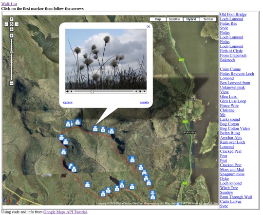
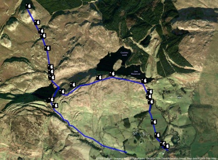
Mapping Walks Again
Since my last walk map post I’ve made a bit of progress. I am now using Trails an iPhone app that:
allows you to record, import and export tracks onto your iPhone.
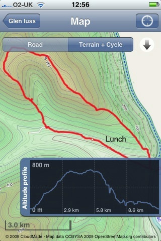
Trails is really nice, it records and show position and altitude. It also allows you to cache map tiles when you have a good connection to use later on a walk.
You can zoom in quite close and it has already been handy in finding out I was going the wrong way in the mist.
Trails allows you to email a track in both kml and gpx format. Clicking the kml file opens the trail in GoogleEarth.
I’ve been using GPSPhotoLinker a free app to add geotags to photos using the gpx track from Trails. Once you have dome that they will be mapped by flickr.
I’ve then been using .SuperCard to read the data from the photos and the gpx track and produce an xml file and set of resized photos. The xml files can be used with the google maps api to show the track and photos on a google map.
I’ve started to put together some webpages to list and show the maps: Mapped Walks.
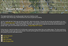
The idea is to end up with a SuperCard project that cuts out some of the steps, it would take in photos and gpx file and upload resized photos and xml file to the web. I just need a bit of time to write and test the scripts.
I have managed to add an mp3 player to some of the google bubbles on one map that plays sound recorded on my phone. The aim is to have pictures, audio video and text. The maps now also have links in the bubbles that take you from one to the next in the correct order, I think this could be come an interesting way to tell a story that travels through space and time.
Toys and Tools Update

Since my move from Sandaig I’ve not had time to sort out this site the way I’d like it. I spent a wee bit of the rainy holiday Monday moving some webpages over here and tidying them up a little. In no particular order:
A flickr CC search toy This is a variation on the flickr search theme, the page searches for flickr creative commons images and shows them. More interestingly it produces the html code to embed the photos with attribution into a webpage or blog. for example the image on the left was produced by a search for tools. The search is fairly underpowered but if you want to give pupils a way to search for images to embed in a blog post and talk about attribution it might help. I hope to improve the page when I get time and a bit more know how.
A Tasty Tumble This is one of my favourite pages it is a fake tumblelog produced from my delicious links. An experiment in presenting data from delicious. Again the code do with more tidying up.
Big Tweets is a simple tweet search and display page that auto updates every minute, it is designed for use with a projector (big text size). It uses the twitter search API and is based on a toy I made for Joe Dale‘s The Isle of Wight Conference.
tags is a page that pulls information for several sources: del.icio.us, technorati, flickr and twitter. For example things tagged glowscotland. I’ve found technorati less useful recently as it doesn’t seem to keep blog posts for as long. This was first developed for teachmeet06.
I’ve also move my wiki over here, it is mostly empty, and I still have various maps to organise (pics, work navigation and some walks ), optimise and sort out. I’ve also got an experimental lifestream home page to finish off.
While none of these applications will set the heather on fire, they give me a lot of fun. They may be useful to others on occasion, but mostly they have served to keep me happily plugging away at the keyboard on rainy afternoons and dull evenings. If you do find anything of value let me know, I work for smiles. They all use various APIs and Libraries provided for free (credit on the various pages) by various developers whose generosity still amazes me, long may they continue.
Glow 1 thinking of Glow 2
My blogging seems to have hit a all time low. I think this is mainly because I used to blog about my classroom practice (with some iPhone, web tech and the odd AppleScript thrown in). I was never one for educational theory I am afraid. I now don’t have a classroom to practise in and blog about.
My more technical posts have never been popular (judging by comments) and fall between absolute beginner and competent so don’t have that wide an audience
Anyway I am going to start a wee Glow post and see what happens.
I’ve blogged about glow before but never had the chance to use it in the classroom. Over the last few weeks I’ve watched North Lanarkshire teachers and pupils start to use glow in practise and have been involved in helping with some of the training.
So far I’ve seen glow have a remarkable effect on some teaching and learning in the first schools to get on board. Teachers have been setting work on glow, children posting work and commenting on other pupils work, locally and further afield. Classes have joined and contributed to National groups and in one case I know off a teacher created a national group within about a week of joining glow. There seems to be a real appetite for getting children involved in all sorts of online collaborating.
One of the favourite activities seem to be the use of Marratech video conferencing through Glow Meet. This is a little ironic as North Lanarkshire has run its own Marratech server for several years. Although this has been used for many projects I think there has been a significant increase in video conferencing in the first couple of months of glow.
I am beginning to think that the most important aspect glow is the way that online collaboration and communication receive promotion and support. There is top down encouragement that is being met by great enthusiasm, almost as if folk have been waiting for the tools unaware that they were already available.
Watching folk take their first steps in glow also highlights some problems with glow and perhaps some pointers for Glow 2.
GUI
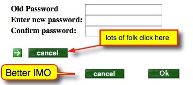
I’ve watch a fair number of people click the cancel button to start all over again by accident. There are a number of similar examples.
The editing of pages in glow is quite a laborious process compared to many web 2 applications there are many examples of slicker interfaces. Compare adding an rss feed to glow and to, say netvibes. Editing information in glow usually seems to involved lots or page reloads and then some scrolling.
Organisation
Groups are hierarchical and difficult to find, interesting groups may be buried inside others. The ability to search group descriptions and the tagging of groups would help this. Some sort of way of filtering and organising groups is needed.
Recently I found a group discussion in glow asking for suggestions for glow 2. I posted a couple of comments but there is very little discussion on the board, perhaps because folk cannot find it?
Data Exchange
One of the strengths of Web 2 applications is the way many of them allow syndication and distribution of data, I can have flickr update in my blog, recent posts from blogs listed in a wiki and so on. At the moment RSS in glow relies on 3rd party scripts or widgets. The is no way, as far as I know, of getting information out of glow in an automatic way. It is hard t ofollow the work of groups you are interested in and no simple ways to share what a group are doing.
Some of this is due to the overriding concern for security but glow does allow for public facing html webpages so the idea of some of glow being open to the public is not beyond the pale.
Wish List
It would be good if Glow 2 was in some way modular, allowing users and groups to add popular and useful open source components, making them private or open to the world. So a group could have a wordpress blog, a phpBB discussion forum, a choice of cms, wikis VLEs etc. etc. Adding the ability for glow to update and add modules would also make Glow a work in progress, in perpetual Beta, rather than a fixed toolset.
I don’t think this is to far fetched, at the moment glow will allow secure access to lots of external content. If this could be expand to give users a choice of the tools it could be wonderful it would help with some of my GUI and data exchange wishes too.
2 Stars & a Wish
We, in Scotland, have an amazing opportunity in Glow which could be even better.
![]() The vision of a national collaboration and communication space for education..
The vision of a national collaboration and communication space for education..
![]() The promotion and support of this collaboration and communication..
The promotion and support of this collaboration and communication..
![]() When the dust settles we have the best tools for the job, and tools that we can swap at will as better ones come along..
When the dust settles we have the best tools for the job, and tools that we can swap at will as better ones come along..
I’d be interested to know what other users have on their glow 2 wishlist? Or if you know where the best place to discuss this would be?
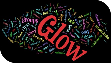
Top image http://www.wordle.net/ with this post’s text.
Growling Tweets
![]()
I’ve messed about with the twitter API before in a ham fisted sort of way (say ObliqueTweet, twitter presenter or Tweets @iowconference08) by basically borrowing various snippets of code, this is another such effort.
I notice an interesting post on Tom Smith’s theOTHERblog: Twitter, Growl, Boosh! In AppleScript!!. I’ve borrowed code from Tom before and was interested in this latest script. The script basically used growl to show tweets for a search or hashtag to be used when watch tv with a group spread over different locations. Tom’s script used the Vienna rss reader as a intermediary for handling the RSS. I recently switched from Vienna to NetNewsWire and didn’t have Vienna installed so took a slightly different approach.
I remembered that someone had mentioned that AppleScript handles xml now (via the ‘System Events’ application) and this seemed like an opportunity to mess about with that and growl.
I’ve cobbled together an applescript that runs and every minute, downloads the latest from a twitter search and growls them. The script is pretty rough at the moment (and in all likelihood will stay that way) but I’ve posted it for view and will upload the actual script once it looks a wee bit better.
The script might be of use in the same way Tom’s is, to display tweets over a shared experience. Or perhaps so make sure I don’t miss an @johnjohnston tweet but don’t get caught up in twitter while I am ‘working’ but really it served to give me a bit more practice with the twitter search API and in starting to learn to parse xml with AppleScript. As twitter become bigger by the second and its API continues to grow I hope one day I’ll do something useful.
twitter image Mirjami Manninen from smashingmagazine
Stykz
I’ve seen quite a few references to Pivot Stickfigure Animator for making simple animations in the classroom,for example these ones from Kent ICT, but never tried it out. Pivot is windows only software and until the Dell refresh in Glasgow primaries I could not install software there. Now I’ve moved to North Lanarkshire where most of the primaries run macs so I’ve not tried it here either.
Last week I was checking some old Supercard links and found reference to Stykz – The first multi-platform stick figure animation program on Sons of Thunder Software developer site. It looks like Stykz has been developed with revolution which is sort of a modern x-platform HyperCard clone. Ken Ray of Sons of Thunder used to be a very helpful contributor to the Supercard mailing list.
Stykz worked well on my mac at home proving to be simple and engaging to use. I can imagine that some children would find it very appealing. Stykz exports to animated gifs and quicktime movie files, in my brief test the movies were a wee bit smaller that the gifs, swf support may be coming, I presume that would make for smaller file sizes.
Stykz is still in Beta, version 1.0 for Mac and windows is expected on the 30th of April the Linux version will follow a month later. The Stykz F.A.Q. lists some interesting features in the works.
The example below show a lack of imagination on my part, but only took a few minutes to produce 70 odd frames and export to a mov file. Well worth a download if you are thinking of teaching the basics of animation and giving your class some fun.
More iPhone locating
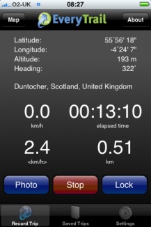
I decided to try a new approach to plotting photos on a map today and use EveryTrail which according to the site:
With this geotracking application, you can record your movements, take geotagged photos, make notes and immediately upload it all to EveryTrail, the leading online community for travel storytelling
The weather was not very nice so i just went a short way from home to the Kilpatrick hills. I started walking and took some photos with EveryTrails as I went, it seemed a smooth and well crafted application. After about 20 minutes I decided I could not remember if I had locked the car to turned around to check. I clicked stop and save in the app and as I was looking at the field to fill in the application quit. On opening it nothing was saved.
On restarting the walk I reverted to using SnailTrail (this application seems to have vanished from the store.)
SnailTrail just lets you save a list of waypoints and email them to yourself. I sure a simple SuperCard project to create the kml file from the list and the photos exif data. I’ve uploaded the the kml file which will open in google earth and imported it into google maps.
I noticed a strange thing when working with the photos, the ones taken in portrait seemed to have lost their exif data. I drag the photos from iPhoto onto my SuperCard project to get the exif data (Via the exiftags commandline app), it seems when iPhoto rotates the images according to the camera’s instructions it loses the exif data. however if you export the files via iPhoto’s file menu you can check a box to include location and the exif data is in the exported files.
Update 2 March 2009 I was trying to incorporate mp3 sound in the kml file but the object tag is not shown by google maps (it is by earth) so I’ve experimented with the maps API and have markers with pictures and sound: Mapped walk which has some potential I think.
![]()
I had a very pleasant location experience this week. I had been trying the iPhone app Tracker to ftp a small webpage with my location to the web (example target=”new”), I was then parsing out the data with php to produce a static google map (example). Then the application was upgraded and the structure of the html file was improved, this of course broke my script. I then emailed the developer Stefan Welebny and asked him if he could have an option just to upload the basic information to a text file. Much to my surprise he wrote back and then updated the application. It now will send the information as parameters to a webpage, in my case a php file. at the moment my file just writes that information out to a text file but I hope to soon be able to record my location to a list and then do other things with it. As I understand it Tracker will send its position every 20 seconds so I could use it by turning the app on for a few seconds to record a location.