Tag: iphone
Taking an iPhone for a walk
I’ve been quite interested in finding out how my iPhone could be used in teaching and learning. last week I and my class making GPS MathTracks inspired by the LearningTracks flickr group and Tom, Andrew and David‘s ideas about Art tracks and spelling with a trackstick. I also read Ollie’s post about Geography Fieldwork with the iPhone.
What I did
Yesterday I was going for a walk and tried out a few ideas with the phone. This is not of course the same as using it with a class but gave me some food for thoughts.
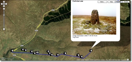
The first thing that I did was record the point of the walk with SnailTrail with which is is simple to collect points and mail them out of the phone. these can be put into a kml template to create a kml file that you can view in google earth or upload and show in google maps. The google map example here show that one or two points went astray. It is easy enough to review these in google earth and remove them. (edit example).
I took a series of photos with the iPhone, these were uploaded to flickr today and automatically placed on the map: Glengoyne to Earl’s Seat set on the map this is a pretty straightforward was of getting the photos onto the map. You could also use the flickr description to add text, the note facility etc as well as discuss the pictures with the comments.

Next I took the photos got the location from the Exif data in the files, I used this to create a kml file and combined that with the snail trail. I also added the time taken and an occasional title to the kml file. I am not sure of the best way of doing this, I made a wee supercard project to script most of this.

Which produces this kml file and looks like this in google maps

The project is pretty rough at the moment and I am sure there are applications out there for doing this, but I wanted to learn a little more about kml files. This sort of thing could be a way of displaying findings for a trip or outdoor activity.
I tweeted occasionally while walking, this produces a list of tweets on Twitter Search as I was using twitterific it was easy to add locations and photos to the tweets, I guess the RSS feed could be parsed to show the pictures and locations or mini maps.

I also added a few notes with YouNote, this application lets you take photos, write notes, record audio and even sketch with a finger. Which would cover most of what you would need on a field trip or excursion. Future editions will let you email notes to get them out of the phone. At the moment you can sync or backup your notes via a desktop application. This results in a zip file on your computer, inside are folders for each note containing multi-media material and xml files with descriptions this information includes geo locations. I suppose that a script could be written to combine this media and xml to create a web page/ map / kml file.
I feel younote is approaching what I would like to see in an iPhone application, if it was combined with a blogging facility or export to a webpage with media it would be ideal.
So what I would like to see would be a combination of the thinks I’ve tried that saved and exported in a usable format. I’ve looked at a few of the blogging application but not found one that does what I want yet.
What I want
My idea application would allow the recording and combining of information in many forms, text, photos and audio recording. It would automatically add location and date and time information. These could be published to a blog and geo rss feed, either on the go, or at a later time if connection to the network is poor. It would be match with a desktop publishing application, this would get the data and media from the phone and allow additions, editing and mashing up, it would output in a multitude of formats.
I’d also like some additions to the iPhone itself:
- Copy and paste
- A camera that can take close ups: I often take photos of flora, fauna, fungi and bones I’d like to take close ups, it might be worth testing putting a magnifying glass in front trick.
- Video
- Temperature recording
- A compass on the Map application
The obvious thing is geography, but I would be more likely to use it for art and maths tracks as mentioned above. It could also be used to record any outing, not one that covers space on a map. I’d love to do a poetry or painting walk, where a class would record reactions to surroundings, typing would probably be limited to haiku(ideal for snapshot poems), but longer ones could be recorded. A class trip to the beach could spark drawing, writing and photos to produce an online gallery.
In the huge number of iPhone apps now available my ideal application may exist, if it does let me know.
GPS MathTracks

After an exciting twittersation between Andrew Brown and Tom Barrett reported on David‘s blog EdCompBlog: Can you guess what it is yet? and Ollie’s iPhone posts (starting with iPhone in Education – Introduction) I was keen to try out gps drawing with my class.
I do not have a gps recorder but I do have an iPhone, I had been a little disappointed with the first GPS app I tried, a freebie, which only worked if you had a connection to the internet so I had invested 59 pence in SnailTrail
SnailTrail records your gps position and saves it to a list, you can add a name to the point and date and time is recorded. The list can sent via email. The points are saved until you delete them. The email arrives with a simple list of points, a second list with names you added and date time and a link to a simple kml template. You can download then open the template, in a text editor, paste in your points and see the trail in Google Earth by opening the template file.
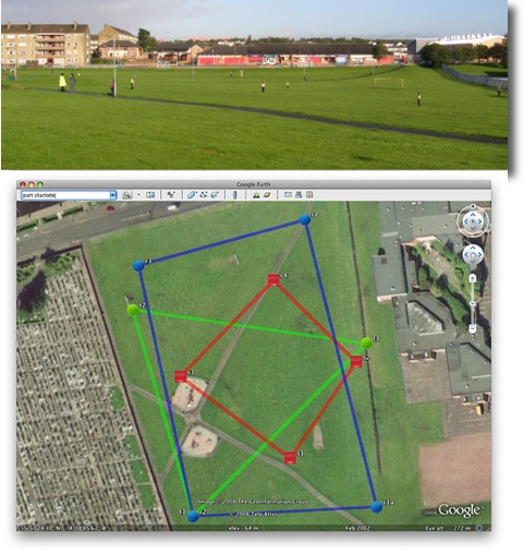
On Tuesday last week I had a few early finishers in Maths draw some 2D shapes onto printouts from Google Earth, of the park next to the school. On Wednesday I split the class into groups, issued colour coded gym bibs and explained that they were challenged to make a shape on the park. We talked over some ideas for making straight lines and figuring out where they should be on the map. The children then scattered very quickly indeed, splashing round a rather wet park. Once they were in position I walked round gathering the locations on my phone. I had planned for one child in each group to run round recording but the field was so wet I though it better to keep them still. We emailed the waypoints to my email and returned to school.
A quick paste of the points into the template showed up a few flaws in my implementation. I had not collected the points in sets of shapes, rather just walked down the field, so they points were all mixed up. The template was designed to show a simple trail rather than shapes.
I took the points and template home and played around a bit, the above screenshot was the result, our five pointed star was a bit of a mess so I left it out.
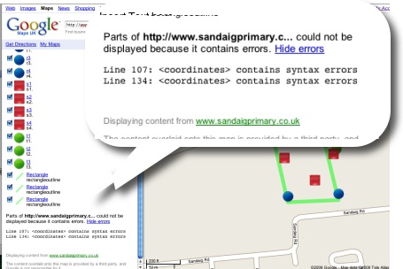
This morning I tried opening the template via google maps, and it showed a couple of errors.

I had another wee dig around the file and now have one that shows up correctly in google maps.
I found it a bit tricky to fix as updating the file did not update in google maps, I had to rename the file with each test to view the results, I have got a lot to learn about kml files.
This is a pretty nice lesson, you can cover quite a lot in it. The properties of shapes, this challenges children to really understand these, working as a team, problem solving, co-ordinates, and a way to introduce latitude and longitude. The children really enjoyed it.
You do need to organise a few things, I had a PSA and link teacher from our local secondary with me, neither had very suitable footwear![]() Next time I’d record the shapes in order and have a template ready to draw the planned shapes as soon as we came back.
Next time I’d record the shapes in order and have a template ready to draw the planned shapes as soon as we came back.
Tom Barrett has started a flickr group LearningTracks for sharing ideas about using tracksticks and other gps devices to draw on Google Earth.
ScotEduBlogs on iPhone
Given the September weekend weather and having a cold I spent a lot of time the weekend in front of my computer.
I spent most of the time following up links from the Scottish Learning Festival and teachmeet and smoothing out some idiosyncrasies in the way that the Sandaig Primary website works.
I also spent some time thinking about ScotEduBlogs.org.uk and footering with my latest toy. This lead to the discovery of iPhone Navigation an example of a web interface for the iPhone, you can see it your browser if you do not have a phone. I was able to create a webpage that grabbed the RSS from ScotEduBlogs and present in using the iPhone Navagation design. I wnt on to discover iui – Google Code based on Joe Hewitt’s iPhone navigation work, iUI has the following features:
- Create Navigational Menus and iPhone interfaces from standard HTML
- Use or knowledge of JavaScript is not required to create basic iPhone pages
- Ability to handle phone orientation changes
- Provide a more “iPhone-like” experience to Web apps (on or off the iPhone)
I also got external links to work better. This ended up on ScotEduBlogs iPhone The pages provides a list of the latest posts on ScotEduBlogs which can be clicked to show the contents of their rss description, link etc. I gives in my opinion quite a nice way to keep up with ScotEdublogs on your phone, you just load the page in Safari. On the iphone you can bookmark a webpage and have it on your iPhone home screen I quickly discovered (thanks google & tweets from dalzinho ) that you can create a custom icon: How To Make iPhone Webclip Icons.

I’ve since discovered there is at least one other kit for creating iPhone ‘web apps’ WebApp.Net. I guess since the opening of the app store on iTunes the web app development has slowed a little but it looks like an interesting area t oplay in if you have not got programming ability.
Of course ScotEduBlogs iPhone is pretty simple, much simpler that the demo apps it is base on, just a basic rss reader, but it has me thinking if there are any developments that could be useful in school, I believe that some schools are buying sets of iPod touches for use in school and this might be an easy way to develop simple specific applications for them. It might be simple enough to create database/ key type pages for animal or plant identification. I also wonder if pupils could create pages for the iPhone/itouch, after seeing Neil Winton present about his pupils text based adventure game in a wiki The Caves Of Mull I wonder if something similar could be done for the iPhone?

