As a bit of a google maps enthusiast I love Tom Barrett’s Maths Maps ideas. It looks to me like a nice way to show some ‘real’ application of maths in an engaging way.
I am still supporting/interfering with an ipod touch project (site gone but not forgotten on the Internet archive). This gave me the excuse a few weekends ago to spend some time messing about with the jQTouch — jQuery plugin which simplifies developing webpages for mobile devices. I am experimenting with building some sort of base site/web app for the touch.
One of the nice things about the iPod Touch is that you can add webpages as ‘applications’ to your home screen. Apple provide a way which jQTouch supports of giving a webpage an icon the idea with the site I am working on, the iPod Playground, is that it should provide an easy way to present links etc to the children this avoids typing long urls into the touch, the webpage could be edited
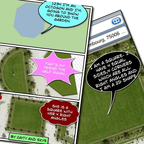
A couple of weeks ago I went over to Glencairn to give the maps a try out. The task I gave the pupils was presented on one of the ‘pages’ of a jQTouch page. Based on one of Tom’s shape problems, the children visited the Jardin du Luxembourg and collected screenshots of different 2D shapes, these were then built into Comics with Comic Touch. We encouraged the children to work in pairs to collect shapes, one child to keep the instructions open the other to click on the link to the map. Then bump the images from the image gatherer to the one with the instructions on his/her screen. The lesson seemed to go pretty well the children accessing the maps, taking pictures and creating comics with out a problem.
I am hoping to get the children to try a Street View problem soon. The Slides from flickr show some of the screens of the jQTouch webpage and a couple of street view images on the touch.
Creating the Tasks
The jQtouch setup is very easy to work with, everything in a ‘site’ is really one page, jQtouch provides a nice standard interface, navigation and animation for that navigation.
It took me a while to figure out how to link to the maps so that I dropped a pin where I wanted it and that pin would have a name on it using the Name and the location in the query seems to work:
Street View Shapes 1

You need to have a pin on the map to get street view to work. On the iPod touch or iPhone you click on the Wee Orange Guy to switch to street view. As an aside I think street view on a browser uses flash, obviously not on the iPod but it is a very smooth experience.
Apple provide quite a few nice tricks to help web app development. You can set an icon for your webpage, so that if folk add it to their home screen it looks like a ‘real’ app. You can also set a splash screen image which will show until the page has loaded when opened as a web app. I have a wee problem with the Flickr Lunes site I blogged about recently if I set: to run in full screen users cannot hold on an image to copy it to their photos, pretty much killing the functionality of the app, so I have had to lose the splash screen. I’ve been working on an ipod/phone version of my A flickr CC search toy called Flickr Search and Stamp this just lets you stamp a flickr photo with attribution. Like Flickr Lunes it only find photos you are allowed to alter so should keep you on the right side of the copyright fairy.

Before August 2014 I used disqus for comments, so this form shows up on older posts.
blog comments powered by Disqus