@vasta on micro.blog posted about satellitestud.io/osm-haiku/app (one of my favourites)

we automated making haikus about places. Looking at every aspect of the surroundings of a point, we can generate a poem about any place in the world.

I’ve been having fun generating random haiku and then matching with photos from my camera roll of the same places.


I’ve blogged before about the wonderful Hmsg Spiral Map a project that combines video, audio and google maps into a mesmerising meditative experience.

Recently I noticed that iPhoto shows the location of videos as well as audio which got me thinking a wee bit. I checked out a few exif tools and found that the location was stored in exif data in the same way as photos.

I already had made some crude tools to map walks on google maps and made an odd foray into adding sounds to the photos: burn, so though I might be able to knit together some video and maps.

After a few false starts I manage to do this:

Loch Hump Screen
A Loch Humphrey Walk

This is a webpage that shows a series of videos with a couple of maps pointing to the location the video was shot at. When one video ends the next is automatically loaded. You can jump around by clicking the numbers.It information: videos urls, locations and time shot is stored in an xml file, this is loaded by some javascript (jquery)

Bideomapfolder

The list of movies and locations are loaded from an xml file that is a very simple list:
<item><file>loch_humprey_02.m4v</file><loc>55.9323,-004.4594</loc><dc> 2011:08:02 21:27:10</dc></item>
I though xml was a good idea as it would allow reuse to display the movie in different ways. As the movies are shown the location is used to show a couple of images using the google maps static api. This first Video Map Experiment was cobbled together using a couple of command line tools (pcastaction, built into Mac OS X and ExifTool by Phil Harvey). I am not knowledgeable about shell stuff but it can often help do interesting things and once you figure it out is easy to reuse.

After a couple of tries I’ve made a Supercard project that sorts this all out, here is what I did to make the A Loch Humphrey Walk

  1. Take videos on iPhone
  2. Trim on iPhone
  3. import into iphoto
  4. Drag videos from iphoto on to a field in a SuperCard project I’ve made.
  5. Click a button on said project which:
    1. Asks me to choose a folder
    2. Gathers locations & date/time from the video files
    3. Makes a copy of videos in the folder, shrinking file size & dimensions (this take a few minutes)
    4. Creates an xml file & and index.html file in the folder to show videos

Video Maps.sc45

I then upload folder to server via ftp.

Getting the JavaScript stuff sorted out took me a wee while and quite a few wrong turnings, but it all seems to work on both Mac & Windows with FireFox, Safari or IE now. I started to write about the gory details in this post, but decided to split them off and I’ll put them up somewhere else sometime soon. I also hope to make the Supercard Project available for anyone who is interested. (If you want to see an early version let me know)

I hope this could be an interesting way to tell a story, record a trip or describe a place. I’d be interested to know what other folk think.

Yest another mapping/iphone post. This might not seem like education but I consider the mapping of walks etc. a sort of trial for possible Teaching and learning activities. At Sandaig I was always interested in blogging trips (Sandaig Netherlands 2008 or Glencoe 06 for example). I am interested in trying to get pupils and groups to tell stories in different ways, audio, text, pictures and video adding location into the mix seems like a good idea. This week i was talking to some of the instructors at Kilbowie Residential Outdoor Centre Oban discussing some of the potential for adding some more ict into their mix through Glow.

On Friday I was going for a walk and decided to try a few different ways of recording the walk centred around the iPhone.

WalkMapBenDonich

As usual I recorded a gpx file and took some photos with the phone for A Mapped Walk

I also took other pictures with my camera and geotagged them once I got home with gpicsync suggested by Dan Stucke in a comment here. gpicsync is a visual front end to exiftool that I’ve mentioned before and works well, unfortunately my iPhone battery gave up early as I was using lots of apps, but a few were mapped by Flickr. The rest taken on the way bak down are untagged.

At the top of the hill i decided to try audioBoo. I love the way Audioboo combines a picture, the audio and a wee map and is simple to use. Unfortunately I didn’t have a good enough signal to post the boo from the hill.

Posterousimgaudio

Instead I turned to posterous. The really good thing about posterous on the iphone is that because it used email you don’t need a signal, the mail app will just wait until it gets one and sends the mail. I found this out on my holiday this year when I seemed to get an occasional signal overnight, making posterous the easiest way to blog.
I’ve also found out how to combine images and audio in an email from the iPhone and because posterous now geo locates your post if there is a location in the exif data of any images posted you get the same effect as audioboo. See Ben Donich – John’s posterous.

The trick is, take a photo, switch to the camera roll and click the share/mail icon. choose the picture and copy it (This will work with several images). Then open up the Voice memos app, recods some audio and then mail it. You can paste the image(s) into your mail and send.

Lifecastingicon

The last thing I tried was the lifecasting app iTunes url, this allows you to choose some photos and then record a narration over a slideshow of the images. The result can be uploaded to youtube or downloaded to your desktop as a m4v file (the app like many others acts like a wee server and puts up a webpage with the movies to download.)

Lifecasting works fairly well, the fact you cannot mail the file is a pity. The other problem is that the slides are shown for a fixed length of time, the example below is the longest, so you have to fit your audio to the show. I did duplicate a couple of images to give myself longer to talk. If the slides could be set to last the length of the audio and you could use mail or the metaweblogAPI to upload them this would be a great app for mobile learning.

lifecasting Example

T“>

I’ve downloaded a couple of other slideshow apps to investigate (at the vast expense of 59 pence each and will try them out whenever I can find them and have a bit of time).

Them ore I use my iPhone the more I believe that a device of this sort has a real place in the classroom for creating the sort of thing I used to use digital cameras, videos, imovie, garage bands and a blog for; the types of activity listed by Margaret Vass in her recent post on Learning, Teaching and ICT » Digital Storytelling ….. and ePortfolios?. We might need to wait a wee while the the right combination of price and feature set but it is getting more interesting every week.

I am continuing to use ExifTool by Phil Harvey for geotagging photos. Is is a wonderful application that has many more features that the basic use I am making of it. Once installed it is simple to use even if you do not usually use commandLine stuff. A quick example using a mac:

  1. Photos in a folder on my desktop called ‘kilsyth hills’
  2. gpx track on the desktop
  3. Open the Terminal application (found in the Utilities folder)
  4. In the terminal you type: exiftool -geotag into the terminal, then drag the gpx track file onto the terminal window, followed by the folder of images, you end up with something like this:
    exiftool -geotag /Users/johnjohn/Desktop/Lecket-hill.gpx /Users/johnjohn/Desktop/kilsyth hills
    in the terminal window, all you need to do is hit return and the application runs through the photos and calculates the gps location of each from the time taken and the gpx track.

If then import the images into iPhoto you can click the info icon on a photos thumbnail to see something like this:

iphoto_geo

And this info will put the photos on the map if you upload them to flickr.

The application came in handy today when I was mapping yesterday’s walk

I am continuing to mess about with this stuff. The last walk I mapped and tweeted brought a ton of great geo information from Geography teacher Kenny73 who blogs at Odblog one post: Odblog: Cellspin in the field covers using cell phone gps and everytrail to produce maps like Ben Vane at EveryTrail and school grounds. The iPhone app I use for creating gpx tracks, trails is integrated with everytrail. This is a simpler way of creating map/gpx/photo mashups than mine but I’ll continue with mine for fun and a bit of flexibility (I can add sounds and video etc to maps). Some sort of everytails system would be easier to to use with a class.

Finally on the geo front I heard about the Eye-Fi Share Wireless 2GB SD Card has been added to the UK amazon store. It went out of stock almost immediately but its features include geotagging of photos! I am not sure if it used gps satellites for this of info about wireless networks to figure out the location, but if it is the former it will stay at the top of my wish list.

Update 02.08.09 On the ADE list David Baugh let me know The eye-fi explore uses triangulation of wireless access points and
mobile towers.
not so useful for walks away from mobile and wifi coverage then.

Since my last walk map post I’ve made a bit of progress. I am now using Trails an iPhone app that:

allows you to record, import and export tracks onto your iPhone.

Trailsscreen

Trails is really nice, it records and show position and altitude. It also allows you to cache map tiles when you have a good connection to use later on a walk.
You can zoom in quite close and it has already been handy in finding out I was going the wrong way in the mist.

Trails allows you to email a track in both kml and gpx format. Clicking the kml file opens the trail in GoogleEarth.

I’ve been using GPSPhotoLinker a free app to add geotags to photos using the gpx track from Trails. Once you have dome that they will be mapped by flickr.

I’ve then been using .SuperCard to read the data from the photos and the gpx track and produce an xml file and set of resized photos. The xml files can be used with the google maps api to show the track and photos on a google map.

I’ve started to put together some webpages to list and show the maps: Mapped Walks.

Walklist tn

The idea is to end up with a SuperCard project that cuts out some of the steps, it would take in photos and gpx file and upload resized photos and xml file to the web. I just need a bit of time to write and test the scripts.

I have managed to add an mp3 player to some of the google bubbles on one map that plays sound recorded on my phone. The aim is to have pictures, audio video and text. The maps now also have links in the bubbles that take you from one to the next in the correct order, I think this could be come an interesting way to tell a story that travels through space and time.

Every Trail

I decided to try a new approach to plotting photos on a map today and use EveryTrail which according to the site:

With this geotracking application, you can record your movements, take geotagged photos, make notes and immediately upload it all to EveryTrail, the leading online community for travel storytelling

The weather was not very nice so i just went a short way from home to the Kilpatrick hills. I started walking and took some photos with EveryTrails as I went, it seemed a smooth and well crafted application. After about 20 minutes I decided I could not remember if I had locked the car to turned around to check. I clicked stop and save in the app and as I was looking at the field to fill in the application quit. On opening it nothing was saved.

On restarting the walk I reverted to using SnailTrail (this application seems to have vanished from the store.)

SnailTrail just lets you save a list of waypoints and email them to yourself. I sure a simple SuperCard project to create the kml file from the list and the photos exif data. I’ve uploaded the the kml file which will open in google earth and imported it into google maps.

googlemapscreenshot

I noticed a strange thing when working with the photos, the ones taken in portrait seemed to have lost their exif data. I drag the photos from iPhoto onto my SuperCard project to get the exif data (Via the exiftags commandline app), it seems when iPhoto rotates the images according to the camera’s instructions it loses the exif data. however if you export the files via iPhoto’s file menu you can check a box to include location and the exif data is in the exported files.

Update 2 March 2009 I was trying to incorporate mp3 sound in the kml file but the object tag is not shown by google maps (it is by earth) so I’ve experimented with the maps API and have markers with pictures and sound: Mapped walk which has some potential I think.

Tracker

I had a very pleasant location experience this week. I had been trying the iPhone app Tracker to ftp a small webpage with my location to the web (example target=”new”), I was then parsing out the data with php to produce a static google map (example). Then the application was upgraded and the structure of the html file was improved, this of course broke my script. I then emailed the developer Stefan Welebny and asked him if he could have an option just to upload the basic information to a text file. Much to my surprise he wrote back and then updated the application. It now will send the information as parameters to a webpage, in my case a php file. at the moment my file just writes that information out to a text file but I hope to soon be able to record my location to a list and then do other things with it. As I understand it Tracker will send its position every 20 seconds so I could use it by turning the app on for a few seconds to record a location.

I’ve been quite interested in finding out how my iPhone could be used in teaching and learning. last week I and my class making GPS MathTracks inspired by the LearningTracks flickr group and Tom, Andrew and David‘s ideas about Art tracks and spelling with a trackstick. I also read Ollie’s post about Geography Fieldwork with the iPhone.

What I did

Yesterday I was going for a walk and tried out a few ideas with the phone. This is not of course the same as using it with a class but gave me some food for thoughts.

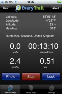
The first thing that I did was record the point of the walk with SnailTrail with which is is simple to collect points and mail them out of the phone. these can be put into a kml template to create a kml file that you can view in google earth or upload and show in google maps. The google map example here show that one or two points went astray. It is easy enough to review these in google earth and remove them. (edit example).

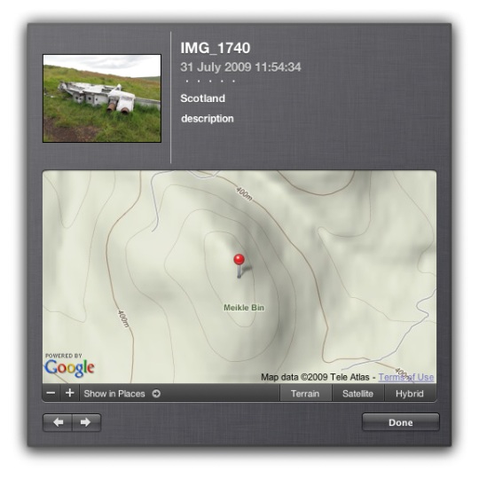
I took a series of photos with the iPhone, these were uploaded to flickr today and automatically placed on the map: Glengoyne to Earl’s Seat set on the map this is a pretty straightforward was of getting the photos onto the map. You could also use the flickr description to add text, the note facility etc as well as discuss the pictures with the comments.

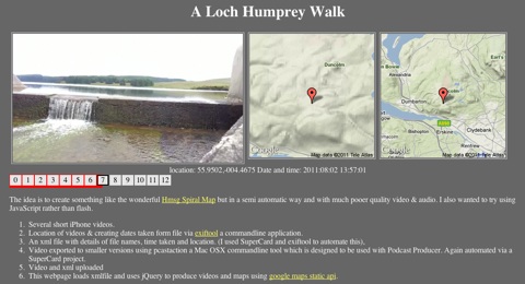
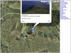
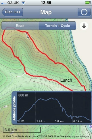
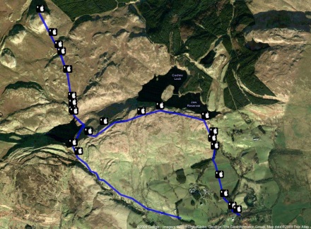
Next I took the photos got the location from the Exif data in the files, I used this to create a kml file and combined that with the snail trail. I also added the time taken and an occasional title to the kml file. I am not sure of the best way of doing this, I made a wee supercard project to script most of this.

Which produces this kml file and looks like this in google maps

The project is pretty rough at the moment and I am sure there are applications out there for doing this, but I wanted to learn a little more about kml files. This sort of thing could be a way of displaying findings for a trip or outdoor activity.

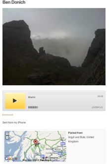
I tweeted occasionally while walking, this produces a list of tweets on Twitter Search as I was using twitterific it was easy to add locations and photos to the tweets, I guess the RSS feed could be parsed to show the pictures and locations or mini maps.

I also added a few notes with YouNote, this application lets you take photos, write notes, record audio and even sketch with a finger. Which would cover most of what you would need on a field trip or excursion. Future editions will let you email notes to get them out of the phone. At the moment you can sync or backup your notes via a desktop application. This results in a zip file on your computer, inside are folders for each note containing multi-media material and xml files with descriptions this information includes geo locations. I suppose that a script could be written to combine this media and xml to create a web page/ map / kml file.

I feel younote is approaching what I would like to see in an iPhone application, if it was combined with a blogging facility or export to a webpage with media it would be ideal.

So what I would like to see would be a combination of the thinks I’ve tried that saved and exported in a usable format. I’ve looked at a few of the blogging application but not found one that does what I want yet.

What I want

My idea application would allow the recording and combining of information in many forms, text, photos and audio recording. It would automatically add location and date and time information. These could be published to a blog and geo rss feed, either on the go, or at a later time if connection to the network is poor. It would be match with a desktop publishing application, this would get the data and media from the phone and allow additions, editing and mashing up, it would output in a multitude of formats.

I’d also like some additions to the iPhone itself:

  • Copy and paste
  • A camera that can take close ups: I often take photos of flora, fauna, fungi and bones I’d like to take close ups, it might be worth testing putting a magnifying glass in front trick.
  • Video
  • Temperature recording
  • A compass on the Map application
What I’d use it for

The obvious thing is geography, but I would be more likely to use it for art and maths tracks as mentioned above. It could also be used to record any outing, not one that covers space on a map. I’d love to do a poetry or painting walk, where a class would record reactions to surroundings, typing would probably be limited to haiku(ideal for snapshot poems), but longer ones could be recorded. A class trip to the beach could spark drawing, writing and photos to produce an online gallery.

In the huge number of iPhone apps now available my ideal application may exist, if it does let me know.

After an exciting twittersation between Andrew Brown and Tom Barrett reported on David‘s blog EdCompBlog: Can you guess what it is yet? and Ollie’s iPhone posts (starting with iPhone in Education – Introduction) I was keen to try out gps drawing with my class.

I do not have a gps recorder but I do have an iPhone, I had been a little disappointed with the first GPS app I tried, a freebie, which only worked if you had a connection to the internet so I had invested 59 pence in SnailTrail

SnailTrail records your gps position and saves it to a list, you can add a name to the point and date and time is recorded. The list can sent via email. The points are saved until you delete them. The email arrives with a simple list of points, a second list with names you added and date time and a link to a simple kml template. You can download then open the template, in a text editor, paste in your points and see the trail in Google Earth by opening the template file.

On Tuesday last week I had a few early finishers in Maths draw some 2D shapes onto printouts from Google Earth, of the park next to the school. On Wednesday I split the class into groups, issued colour coded gym bibs and explained that they were challenged to make a shape on the park. We talked over some ideas for making straight lines and figuring out where they should be on the map. The children then scattered very quickly indeed, splashing round a rather wet park. Once they were in position I walked round gathering the locations on my phone. I had planned for one child in each group to run round recording but the field was so wet I though it better to keep them still. We emailed the waypoints to my email and returned to school.

A quick paste of the points into the template showed up a few flaws in my implementation. I had not collected the points in sets of shapes, rather just walked down the field, so they points were all mixed up. The template was designed to show a simple trail rather than shapes.

I took the points and template home and played around a bit, the above screenshot was the result, our five pointed star was a bit of a mess so I left it out.

This morning I tried opening the template via google maps, and it showed a couple of errors.

I had another wee dig around the file and now have one that shows up correctly in google maps.

I found it a bit tricky to fix as updating the file did not update in google maps, I had to rename the file with each test to view the results, I have got a lot to learn about kml files.

This is a pretty nice lesson, you can cover quite a lot in it. The properties of shapes, this challenges children to really understand these, working as a team, problem solving, co-ordinates, and a way to introduce latitude and longitude. The children really enjoyed it.

You do need to organise a few things, I had a PSA and link teacher from our local secondary with me, neither had very suitable footwear;-) 
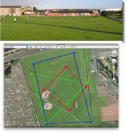
Next time I’d record the shapes in order and have a template ready to draw the planned shapes as soon as we came back.

Tom Barrett has started a flickr group LearningTracks for sharing ideas about using tracksticks and other gps devices to draw on Google Earth.

The questions are at the end feel free to skip down there if you know anything about gps.

I spent quite a while over a year ago messing with the google maps api. eventually I made an interface for creating maps, uploading photos and placing them on the map. This gave me a lot of fun, but I found it too time consuming for children to use.
The earlier this year Google My Maps came out which was a lot neater than my effort, and I’ve used it a few times, mostly pasting in the links flickr provides to add photos.

Cort-ma-Law from Lecket hill This week I stared another one with a few photos from a walk.
I was a bit frustrated about placing the photos on the map as I found it hard to figure out where place where in the rather featureless Campsies.

Flickr map Sorry

I switched to using flickr own maps but found them it a bit slow (that might be my aging mac).
I found it even more difficult to get the photos placed with any accuracy on flickr maps, although the interface for adding and looking at the photos is very slick, especially when you grab a bunch of pictures and throw them on a single spot.
Perhaps I just do not go far enough so need to much detail on a map to make my walk look like a walk rather than a spot.

All this made me think about my previous experiments, especially as there was an article in macuser about using the flickr and google maps apis combined. I had just finished using phpflickr to make a community gallery so though this might be quite quick.

Unfortunately the macuser article relies on a flickr api flickr.photos.geo.getLocation which depends on you having placed the photo on the flickr map (I was beginning to go round in circles).

Then I remembered Adam Burt‘s Applescript for getting geo tags from Google Earth ready for pasting into flickr. Adam does amazing things with blogs, google Earth/maps and geoblogging.
The appleScript copies to the clipboard geo tags of the location showing on google earth at that time.
It is much easier to figure out where you are on google earth, it has a smoother gui than google maps and a better resolution (of where I was at least). so I geotagged a bunch of photos, grabbed a new google maps API key and got busy.

Flickr googlemap mashup

Of course at that time I didn’t know about flickr.photos.geo.getLocation depending on flickr maps.And I didn’t know a tag geo:lon=-4.704382114809 would be returned from the API as machine_tags=”geo:lon=4704382114809 geo:lat=56258859999999″ ie without the minus sign or point so I spent a fair bit of time staring at a blank map, as the google maps API didn’t understand what I was sending to it. Anyway to cut a very long afternoon short, I delved deeper than I had been before into the data returned from flickr.photos.getInfo and finally clunked together a couple of files, the first uses phpflickr to grab the info from flickr and store it in a file, the second pulls that info using the google maps api and create a map.
I did try pulling the information and creating the map all at once, but that took too long. The data from flickr obviously does not need to be updated very often so that job was hived off, speeding up the maps creation. The unfinished product is here: John’s Flickr Map Mashup.

This is just scratching the surface of what could be done, it would be better maybe to create different maps for different days or for particular tags. if all of my tagged photos go on the same map it might eventually be too crowded and need some pagination.

Help wanted: I’d like to know a bit more about geo tagging and perhaps GPS:

  1. Would it be possible to get data from a GPS device and add it to the EXIF data of a photo before uploading it?
  2. Does Flickr undersatand embeded gps data?
  3. Is there a cheap enough GPS device that would work with a mac?

I am thinking of a work flow that includes the tagging of photos before uploading, maybe in iphoto with AppleScript or a SuperCard project, I think I’ve done some EXIF data extracting so imagine that adding can’t be that much harder.

Any ideas that do not involve a lot of expense gratefully received.