
I decided to try a new approach to plotting photos on a map today and use EveryTrail which according to the site:
With this geotracking application, you can record your movements, take geotagged photos, make notes and immediately upload it all to EveryTrail, the leading online community for travel storytelling
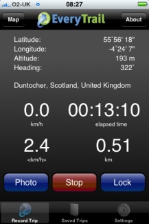
The weather was not very nice so i just went a short way from home to the Kilpatrick hills. I started walking and took some photos with EveryTrails as I went, it seemed a smooth and well crafted application. After about 20 minutes I decided I could not remember if I had locked the car to turned around to check. I clicked stop and save in the app and as I was looking at the field to fill in the application quit. On opening it nothing was saved.
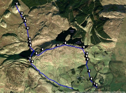
On restarting the walk I reverted to using SnailTrail (this application seems to have vanished from the store.)
SnailTrail just lets you save a list of waypoints and email them to yourself. I sure a simple SuperCard project to create the kml file from the list and the photos exif data. I’ve uploaded the the kml file which will open in google earth and imported it into google maps.
I noticed a strange thing when working with the photos, the ones taken in portrait seemed to have lost their exif data. I drag the photos from iPhoto onto my SuperCard project to get the exif data (Via the exiftags commandline app), it seems when iPhoto rotates the images according to the camera’s instructions it loses the exif data. however if you export the files via iPhoto’s file menu you can check a box to include location and the exif data is in the exported files.
Update 2 March 2009 I was trying to incorporate mp3 sound in the kml file but the object tag is not shown by google maps (it is by earth) so I’ve experimented with the maps API and have markers with pictures and sound: Mapped walk which has some potential I think.
![]()
I had a very pleasant location experience this week. I had been trying the iPhone app Tracker to ftp a small webpage with my location to the web (example target=”new”), I was then parsing out the data with php to produce a static google map (example). Then the application was upgraded and the structure of the html file was improved, this of course broke my script. I then emailed the developer Stefan Welebny and asked him if he could have an option just to upload the basic information to a text file. Much to my surprise he wrote back and then updated the application. It now will send the information as parameters to a webpage, in my case a php file. at the moment my file just writes that information out to a text file but I hope to soon be able to record my location to a list and then do other things with it. As I understand it Tracker will send its position every 20 seconds so I could use it by turning the app on for a few seconds to record a location.
Before August 2014 I used disqus for comments, so this form shows up on older posts.
blog comments powered by Disqus